- What causes a hurricane? Why is a hurricane so destructive?
- question from Sally Lee
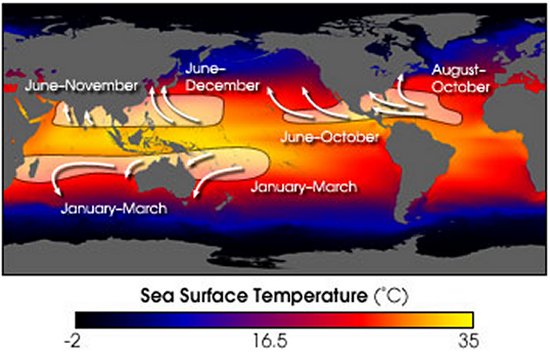
Hurricane or cyclone seasons in the Atlantic, Pacific, and Indian Oceans
The cluster of thunderstorms that may eventually grow into a hurricane is formed during the first stage of cyclone development known as a tropical disturbance. A tropical disturbance is created when surface winds converge to create instabilities in the atmosphere that trigger the formation of storms. This situation is common near the equator where the easterly trade winds converge to create thunderstorms in a region called the Inter-Tropical Convergence Zone (ITCZ). Most Atlantic hurricanes form from another kind of tropical disturbance called the easterly wave. This disturbance emerges in the tropical easterlies and creates "waves" in the trade winds that travel toward the west. This wave causes the winds to converge together and encourages the formation of thunderstorms on the east side of the wave.
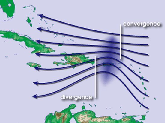
Easterly wave creating a convergence of trade winds in the Caribbean Sea
The addition of heat causes atmospheric gases to expand, so the air inside the depression becomes less dense and rises tens of thousands of feet above the ocean surface. As its altitude increases, the air cools causing more water vapor to condense and release its heat, which draws in yet more air to rise upward. This process repeats itself again and again causing the temperature at the center of the storm to continually increase and driving the surface pressure even lower. As the pressure drops, more low-altitude air that is rich in water vapor is pulled inward to release yet more heat into the center of the storm.
This process becomes a chain reaction that pulls hot, humid air from the surface of the ocean up to high altitude where the air becomes cold and water vapor condenses into thick clouds. This growing air mass becomes increasingly dense causing the atmospheric pressure to grow. The increasing pressure pushes the growing mass of clouds outward away from the center to create the spiraling bands of clouds that hurricanes are known for. As the air mass spirals outward, its pressure decreases and the dense air plunges back towards the ocean surface where it started. It now picks up vapor again from the warm waters below and is sucked back into the center of the depression to begin its journey anew. As the cycle continues, the surface pressure at the center drops lower and lower causing the circulation of the air to strengthen and the winds to grow increasingly stronger.
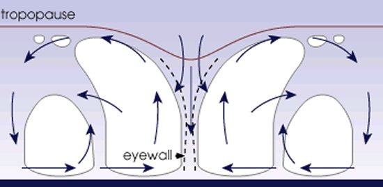
Cycle of circulating air releasing heat and condensation to create a tropical cyclone
It is also during the tropical storm phase that the storm begins to take on its characteristic appearance as a rotating spiral with bands of clouds circulating around the point of lowest surface pressure at its center. The tropical storms that form in the northern hemisphere always rotate in a counter-clockwise direction due to the Coriolis force induced by Earth's rotation. Tropical storms of the southern hemisphere, however, rotate clockwise as a result of the opposing Coriolis effect.
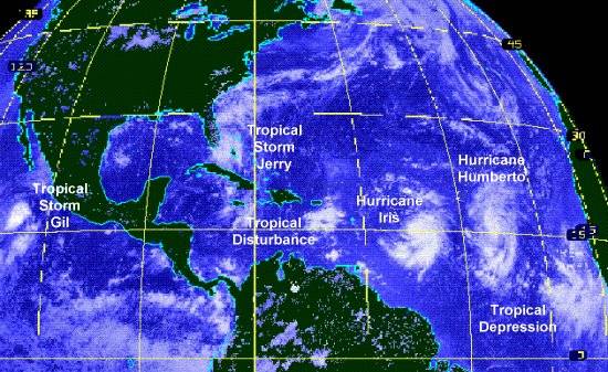
August 1995 satellite photo of tropical cyclones in various stages of development
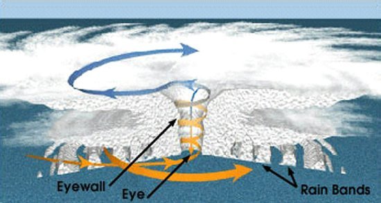
Fully formed tropical cyclone with an eye, eyewall, and circulating rain bands
Hurricanes and cyclones typically move westward at a speed of about 10 mph (16 km/h) during the early stages of formation. The storms are steered in this direction by the trade winds that occur near the equator and blow towards the west. The Coriolis effect that determines the direction of the cyclone's circulation also influences the direction the storm takes. As a storm moves further from the equator, its course is turned towards the poles and the cyclone curves towards the north in the northern hemisphere or towards the south below the equator.
The storm may be deflected, however, due to the influence of high and low pressure systems within the atmosphere. These pressure systems may keep the storm on a westerly path or may even be powerful enough to move the cyclone towards the east. For example, some Atlantic hurricanes continue on a straight path into Mexico or Central America instead of turning north towards the US. Others are moved northeast where they skirt the US East Coast but never make landfall. In 2004, Hurricane Ivan and its remnants followed a particularly unusual path that took it through the Gulf of Mexico, north into the US, east back into the Atlantic, south towards the coast of Florida, west across the state and back into the Gulf, and making a landfall in Texas as a tropical storm before finally dying out.
The destructive power of hurricanes and cyclones comes from four primary factors. The strong winds generated inside the storm have the power to severely damage structures in their own right. The winds also pick up loose objects converting the debris into powerful projectiles that can do considerable damage. The second destructive factor is the heavy rains that the thunderstorms inside a tropical cyclone bring. Rains most often cause flooding or landslides that wash out communities and block roads. The rotating motion of cyclones can also lead to the formation of tornados with strong damaging winds of their own.
The final and usually most destructive force wrought by a hurricane is called the storm surge. The storm surge is a rise in the level of the ocean that can reach as much as 35 ft (10.5 m) above normal. The surge is created by strong winds that push up a wall of water ahead of the cyclone and washes inland as the storm moves ashore. The storm surge is created on the right-hand side of the cyclone (left-hand side in the southern hemisphere) ahead of that portion of the storm rotating towards the coast. The destructive power of the surge comes from its ability to wash over shorelines, flood areas far inland, and then rush back out to sea as the waters subside.
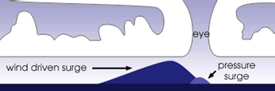
Storm surge created by a tropical cyclone
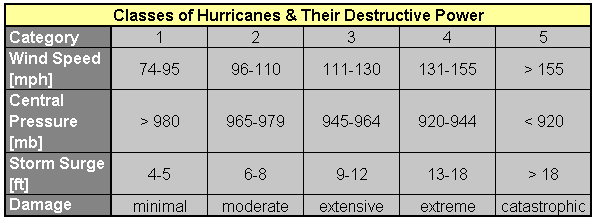
Categories of hurricanes and their relative destructive power
If the storm does grow into a cyclone, several factors can cause it to lose strength and dissipate. Moving over land deprives the storm of the warm water on which it depends, and most hurricanes decay to a low-pressure system within a couple days of landfall. Similarly, the storm may remain in the same waters for too long and consume all the available heat or move into colder waters that cannot supply the heat needed to keep the cyclone active.
As a hurricane decays, it again reverts through phases similar to those that first formed the tropical cyclone. Hurricane Katrina, for example, was first named on 24 August 2005 when it reached tropical storm strength off the Atlantic coast of Florida. Tropical Storm Katrina grew to hurricane strength the following day just before moving ashore through southern Florida as a Category 1 hurricane. Katrina soon weakened to a tropical storm again after making landfall, but regained its strength once it reached the warm waters of the Gulf of Mexico on 26 August. Hurricane Katrina spent three days over the Gulf and rapidly increased in strength as it turned north towards the Gulf Coast. Katrina strengthened from Category 2 to Category 3 on the 27th, Category 4 on the 28th, and a massive Category 5 with sustained winds of 175 mph (280 km/h) later that day.
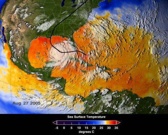
Hurricane Katrina and an approximation of its path
Although Atlantic hurricanes tend to be the best known in the US, the most active cyclone areas are in the Pacific and Indian Oceans. The greatest number of tropical storms forms in the northwestern Pacific and threaten East Asia. On average, about 27 tropical storms appear in this region of the world each year and about 17 of these become typhoons. The second most active region is the eastern Pacific where storms form off the coast of Mexico and move northwest towards Hawaii before eventually dissipating in the cold waters south of Alaska. This part of the world experiences an average of 16 tropical storms and nine hurricanes per year. The southwest Indian Ocean is also a very active area where a yearly average of 13 tropical storms and seven cyclones pose a menace to Madagascar and the east coast of Africa. The fourth most active region is the northern Atlantic where about eleven tropical storms and six hurricanes form in a typical year.
Other regions known for tropical cyclone activity include the southwestern Pacific where storms threaten Oceania and eastern Australia as well as the southeastern Indian Ocean that generates cyclones striking western Australia. The northern Indian Ocean generally produces few storms but these have been some of the most destructive in history due to the large death tolls wrought in nations like India, Bangladesh, Thailand, and Sri Lanka. The southern Atlantic Ocean is also an area of tropical activity but tends to produce very few storms.
Cyclonic storms are not unique to Earth either. The gas giants of the outer solar system also exhibit similar storm activity. These storms feed off internal heating and convective currents through the dense gases that make up the planet's atmosphere. Although giant storms have been seen on Saturn and Neptune, they pale in comparison to the massive storms on Jupiter. The most famous by far is the Great Red Spot that circles the planet's southern hemisphere. The storm was discovered by British astronomer Robert Hooke in 1664 and has been raging for over 340 years.
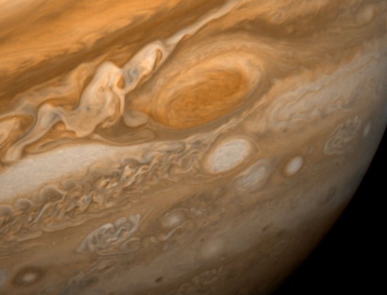
Jupiter's Great Red Spot and numerous smaller storms
If you would like to learn more about the science and history of hurricanes and tropical cyclones, some good sources include Hurricane Watch: Forecasting the Deadliest Storms on Earth by Jack Williams and Bob Sheets as well as the CD-ROM set 21st Century Complete Guide to Hurricanes, Cyclones, Typhoons, and Tropical Storms. A nice book to introduce kids to the subject is Hurricanes by Seymour Simon.
- answer by Molly Swanson
- answer by Joe Yoon, 11 September 2005
A Note About Willy-Willies:
We have received a few messages from Australians who point out that the use of the term "willy-willy" as another name for a cyclone is only a myth. They say the term instead refers to small whirlwinds or dust devils that bear little resemblance to an enormous hurricane. Nevertheless, countless textbooks, encyclopedias, weather sources, and official websites from prestigious institutions like NASA and NOAA continue to include "willy-willy" as a name used for cyclones in Australia. Why is this?
Upon conducting research with the assistance of a meteorology professor in Australia, we've learned that the truth lies somewhere in between. Meteorological records from the 1800s and early 1900s make it clear that "willy-willy" was indeed used extensively as a synonym for cyclone or hurricane. A good example can be found in the report Australian Hurricanes and Related Storms by H. A. Hunt published by the Commonwealth Meteorologist in 1925. The report includes a map with a caption reading "Track of a Typical 'Willy-Willy'" that clearly illustrates the path of a tropical cyclone. Still more examples can be found in a document from the Australian weather bureau titled Tropical Cyclonic Storms on the North-West Coast of Western Australia from the 1910s. Quotes from this report include:
"When the barometer shows signs of falling with an easterly wind, conditions are conducive to the development or approach of willy-willies, and precautions should be taken accordingly.""As a precautionary measure during the willy-willy season, hourly readings of the barometer and the direction of the wind should be made by mariners and entered in the ships log."Nevertheless, the meaning of the term willy-willy is not always clear in these documents. Though there are many cases where willy-willy is used interchangeably with the words hurricane and cyclone, there are others where it appears to be meant as a whirlwind or tornado spawned by a hurricane, similar to the modern definition of the term. It would seem that the meaning of the phrase willy-willy gradually evolved during the twentieth century and it was no longer used in conjunction with cyclones after the 1930s. Today, "willy-willy" is used exclusively for small whirlwinds, dust clouds, or dirt devils while large tropical storms like hurricanes are known as cyclones.
"12-18 Jan 1899: S.S. Tangier encountered willy-willy on 12th off N.W. coast"
- answer by Greg Alexander, 14 September 2005

It is very important to ensure better Typhoon Preparedness
ReplyDelete